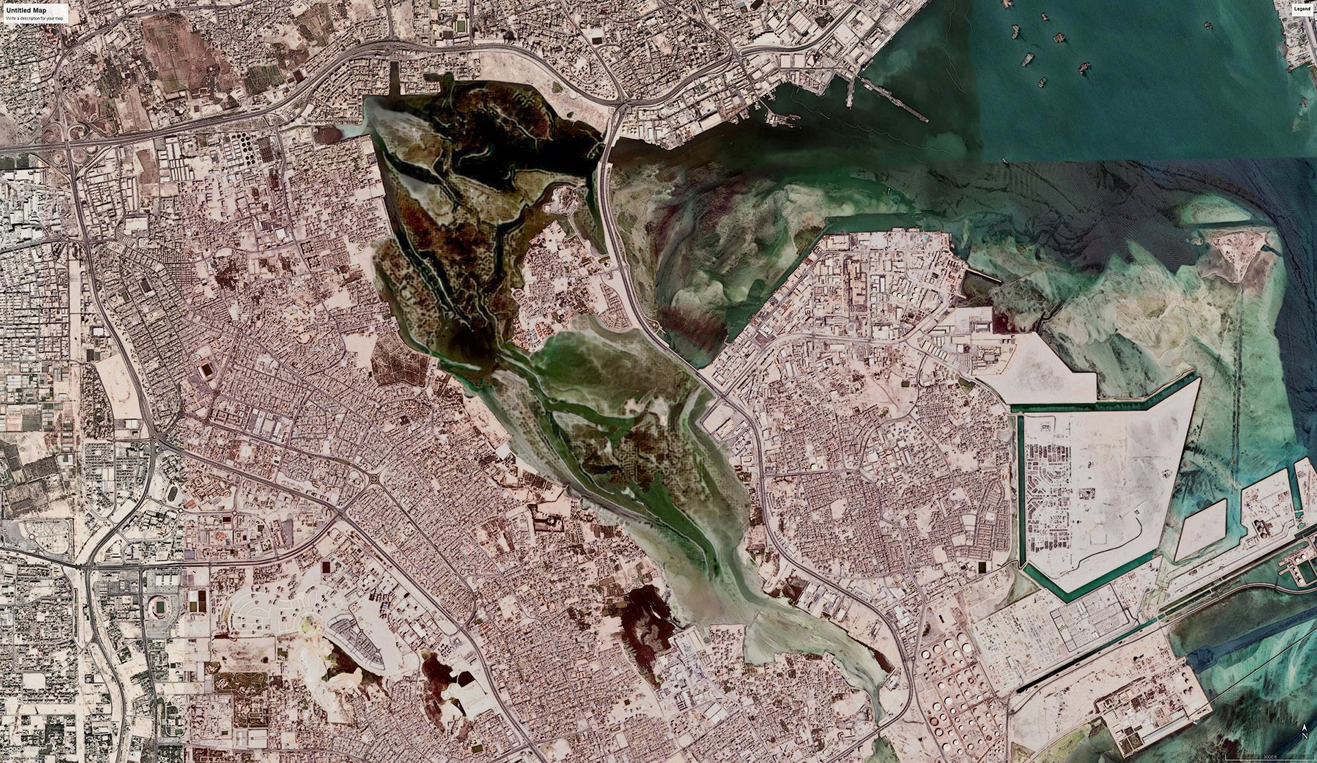
Tubli Bay’s Mangroves
Computational Design for Coastal Restoration
Computational Ecology
Disclaimer: This study presents a computational approach to simulating mangrove-inspired landforms; however, comprehensive development of this method requires collaboration with marine ecologists, botanists, and environmental engineers to ensure ecological accuracy and functionality. The technique outlined here is intended as a scalable model for coastal landform development, with the understanding that further interdisciplinary input will be essential.
“artificial mangroves could offset up to 15,000 Mg CO2 annually, achieving 85% fidelity to natural textures.”
This study explores a computational approach for designing artificial mangrove landforms tailored to Bahrain’s unique coastal environment, targeting key challenges like coastal erosion and carbon sequestration. This research proposes an adaptable model for creating resilient, mangrove-inspired structures that harmonize with Bahrain’s geographical features by employing techniques such as edge detection, depth mapping, and neural style transfer.
Coastal Crisis as Catalyst
Bahrain’s mangrove cover has seen a 95% reduction since 1967 due to extensive land reclamation and urban expansion, reducing mangrove areas from 328 hectares to 48 hectares in 2020. This decline has dramatically lowered the region’s carbon sequestration capacity, a critical function of natural mangroves. This project hypothesizes that computationally derived mangrove-inspired landforms can offset some of these environmental impacts by replicating natural mangroves’ carbon capture, filtration, and shoreline stabilization roles. With new government-led efforts aimed at expanding mangrove cover, this computational approach aims to enhance coastal resilience in a scientifically informed, ecologically inspired manner.
Ecologies of Replication
Mangrove ecosystems, particularly the Avicennia marina in Bahrain, are vital carbon sinks, but global threats like climate-induced sea-level rise, eutrophication, and anthropogenic pressures have accelerated their decline. Recent advancements in GIS, high-resolution satellite imagery, and neural networks for pattern replication offer new approaches to analyzing and digitally reconstructing mangrove topographies. Influential studies on global mangrove degradation and Bahrain’s recent mangrove preservation initiatives establish the groundwork for applying computational design in ecological resilience strategies.
The Computation of Living Systems
This project begins by processing high-resolution satellite imagery, converting Bahrain’s coastal topography into a digital terrain through depth mapping and feature isolation. Key ecological features such as water channels and tidal zones are mapped using the Canny Edge Detection method, forming the outline for the artificial landscape. A neural style transfer model, trained on images of mangrove root patterns, overlays these isolated forms to integrate mangrove-inspired textures and densities. Throughout this process, spatial parameters are tuned iteratively to harmonize the natural contours of Bahrain’s coastal geography with stylized mangrove patterns, ensuring the final output is ecologically responsive and architecturally coherent.
The Politics of Artificial Ecology
The output, achieving an 85% replication fidelity with natural mangrove texture and density, demonstrates how artificial mangrove forms can contribute to carbon sequestration and habitat stabilization. Estimates suggest that these artificial landscapes could sequester approximately 15,000 Mg CO2 annually if implemented at scale in restoration areas. While visually akin to natural mangroves, these synthetic structures highlight the limitations of current computational methods, particularly in recreating adaptive ecological behaviors. Though aesthetic outcomes align with ecological objectives, further integration of biochemical and environmental adaptability in digital models is necessary for functional authenticity.
Simulated Ecologies as Adaptive Infrastructure
Unlike traditional infrastructure, these computationally designed landforms are shaped to respond to natural processes, offering potential benefits such as fostering biodiversity and stabilizing coastal soils. By simulating the filtration and carbon-capturing functions of mangroves, this method allows for an infrastructure that supports both ecological and urban needs. The adaptability of these designs positions them as a valuable model for rethinking coastal infrastructure in response to climate-related risks, creating resilient environments that align built and natural systems.
Digital Ecologies and the Limits of Simulation
Creating computationally derived mangrove landscapes highlights the precision and limitations of digital ecologies. While GIS data, depth mapping, and neural networks allow replication of mangrove forms, they cannot fully emulate the adaptive responses of living systems to tides, sediment, and nutrient flows. This challenge emphasizes the potential for future hybrid designs, blending computational structures with biological functions. As experimental frameworks, these synthetic landscapes push the boundaries of architecture’s role in environmental resilience, aiming to meet Bahrain’s ecological needs through innovative, symbiotic solutions.
Towards a Manufactured Ecology
This study proposes that computational design can provide an effective framework for ecological architecture, specifically in addressing coastal resilience and environmental degradation. Future research will explore scaling these artificial mangrove landscapes across broader areas, incorporating adaptive environmental sensors to respond to real-time changes. Collaborations with conservation initiatives and governmental bodies may facilitate the deployment of these fabricated ecologies, advancing Bahrain’s mangrove restoration goals and establishing a replicable model for resilient coastal architecture globally.
Photographs of Tubli Bay’s remaining mangrove
Satellite image of the study area from 1984
Satellite image of the study area from 2020
Ecologies of Imitation:
Synthetic Mangrove via Neural Style Transfer
Detailed steps for creating mangrove-inspired landforms using neural style transfer. The Input Form (satellite image) and Input Style (mangrove texture) initiate the process. Island Form and Mangrove Pattern layers extract water channels and land contours, setting a base for style integration.
This grid displays iterative style transfer across the site (A, B, C), leading to a refined output. Each row illustrates two progression from initial satellite imagery through variations in mangrove-style application.
Mapping Adaptive Thresholds:
A Visual Syntax for Coastal Restoration
This diagram outlines the layered process from input edge and depth analysis to the mangrove pattern application, creating a synthesized coastal form. Depth mapping and texture integration allow for the transformation of raw topographic data into ecologically resonant structures.
This grid presents a sequence of edge extraction of the style transfer. The variations reveal the computational adjustments needed to create adaptive, synthetic landscapes to support coastal resilience.
Tubli Bay’s mangrove area changes from 1967 to 2020
AI generated proposal for Tubli Bay’s artificial mangrove forest
Drawing of the proposal
Island’s close-ups
Serial cross-section of the proposal


