A Dream for a Techno-Natural State
Toward New Forms of Ecological Monumentality in Bahrain
Reclamation
A WEI+ZKA Project

Disclaimer: While land reclamation can have severe environmental impacts—disrupting marine ecosystems, altering tidal flows, and contributing to the degradation of natural habitats—it remains an ongoing and central practice in Bahrain’s urban expansion. This project does not overlook the ecological risks inherent in reclamation; instead, it seeks to explore possibilities for mitigating these effects through a more responsible approach. By integrating advanced technologies, such as machine learning and ecological restoration, this vision for Bahrain reimagines land reclamation as an opportunity to create a more sustainable, resilient, and ecologically sensitive future.
“What if Bahrain’s landforms were not just picturesque but
infrastructural—prototypical forms for a new urban paradigm?”
A Monumental Opportunity for Bahrain’s Future
The creation of land is itself a monumental act—an endeavor that is both expansive in scale and profound in its implications. In Bahrain, where nearly 18% of its total landmass has resulted from aggressive reclamation projects since 1987, the very ground beneath the population’s feet is a testament to the shifting relationship between the natural and the artificial. Yet, Bahrain’s marriage of land and monumentality is conspicuously incomplete, focusing primarily on vertical gestures: skyscrapers, towers, and the symbolic height of economic success. This essay considers the possibility of reversing this trend—of turning to landforms and ecological systems as infrastructural, techno-natural dreams that redefine monumentality in the 21st century. The proposition hinges on merging the picturesque and the infrastructural to generate urban futures that challenge both architectural and geopolitical scales.
Bahrain is an archipelago of contrasts—natural and artificial islands in constant flux, rising and expanding in a competitive regional quest for distinction. The pseudo-monumental developments along the Arabian Peninsula’s coastlines are landscapes and land art, where skyscrapers rise from manufactured islands. The land becomes sculptural, driven by the region’s thirst for vertical expansion, resulting in a landscape where artificial islands and skyscrapers compete. Yet, despite the monumental ambitions, Bahrain remains a relatively low-lying country, with its highest point reaching just 134 meters.
This project takes Bahrain as a testbed for alternative monumentality. Here, reclamation projects—traditionally regarded as feats of engineering, architecture, and economic growth—are repositioned as landscapes of potential, more infrastructural than symbolic. Once integral to the island’s survival, architects could reimagine ecological systems to contribute to this shift. How might Bahrain transform its now-defunct springs and desiccated aquifers into new ecological systems that serve urban needs while becoming sites of public life and collective memory?
A Sectional Irrigation Landscape
A new form of monumentality in Bahrain could stem from its past. Historically, the island’s ancient irrigation systems sustained agriculture and a thriving ecosystem of birds, fish, and small mammals. Before these systems collapsed under the weight of overuse, they were infrastructural monuments, providing lifeblood to Bahrain’s inhabitants and structuring daily life. Reviving this infrastructure, albeit with a technological twist, could position Bahrain as a leader in techno-natural urbanism. In this future, ecosystems will be functional and celebrated as public spaces of aesthetic and civic importance.
Recent experiments in StyleGAN demonstrate the possibility of blending historical visual aesthetics with speculative futures. In the case of Bahrain, this manifests through reimagined mountain islands shaped through data sets of Viollet-le-Duc, John Ruskin, and Victor Hugo. These speculative landscapes evoke the grandeur of natural forms, such as the mountains typically absent from Bahrain’s topography. They suggest landforms themselves can carry the same symbolic weight as any tower or skyscraper. The current project envisions these mountains as infrastructural hubs, collecting and distributing water to desalination systems while also serving as monuments in their own right.
This blending of technology and nature—pixelated urbanism—creates a grid-like landform that supports a more diverse infrastructural system. The proposed pixel-based techno-natural twin operates on two registers: first, as a new infrastructural and ecological system, and second, as a symbolic gesture, creating a visible and measurable transformation of Bahrain’s terrain. Where once the archipelago’s highest point was 134 meters, these new mountainous landforms could rival even the tallest skyscrapers in height, creating a novel horizontality to complement the vertical ambitions of its urban centers.
Toward a Techno-Natural Dream
What if Bahrain’s landforms were not just picturesque but infrastructural—prototypical forms for a new urban paradigm? Bahrain’s historical irrigation and water management systems offer a compelling precedent for how the country might move beyond the current trend of purely symbolic land reclamation. Bahrain’s future may lie not in the race for vertical monuments but in reimagining its relationship to land and sea, water and air, in ways that merge the natural and the artificial, the ecological and the technological. The techno-natural dream suggests a hybrid system where infrastructural necessities—water desalination, urban expansion, and transportation—are embedded within monumental landforms that are both functional and symbolic.
Bahrain’s existing islands, altered through technological intervention and ecological imagination, provide the ideal laboratory for testing this hypothesis. The proposal to build a techno-natural twin of Bahrain points to a new way of conceiving land. As a techno-natural dream, it redefines monumentality for a world increasingly aware of the limits of traditional infrastructure, proposing instead a future where landforms are the infrastructure of the future, poised to support not just the weight of civilization but its aspirations.

Satellite images of Bahrain, 1990

Satellite images of Bahrain, 2008


Proposed Public Transportation Network, issued in 2011
Plan for Bahrain, issued in 2016

Gardens around Adhari Spring, 1960s

People swimming in Adhari Spring, 1970s

Smoke Mountain, Date Unknown

Model of Salman Industrial City, 2012

Render of Amwaj Islands in Bahrain, 2006
Machine Learning Landscapes:
Reimagining Mountainous Islands

The resulting mountain imagery emerged from StyleGAN training, leveraging a data set composed of outline studies by Viollet-le-Duc, John Ruskin, and Victor Hugo. These explorations investigate how historical aesthetics can influence speculative natural forms.

StyleGAN training produced mountain islands, drawing from a diverse data set of 56 existing mountain islands sourced from Google Earth. These digital landscapes blur the boundary between real and imagined geographies, proposing new monumental landforms.
Mountain-Stationed Desalination:
Water Systems and Topography

Close-up of the central mountain desalination plant, showcasing the network of distribution streams designed to optimize water flow through natural gradients.

Drawing of existing Bahrain alongside its techno-natural twin, illustrating mountainous topography and a gravity-fed system for desalinating and distributing water.
Around 2,000 desalination plants operate along the shallow waters of the Arabian coast. Bahrain, while not unique in this reliance, presents an ideal case study due to its small archipelagic nature, offering insights into challenges that are likely to extend beyond the Middle East.

Crater-like mountain top serves as a water storage basin for the initial phase of desalination, overlaid with a detailed water distribution system.
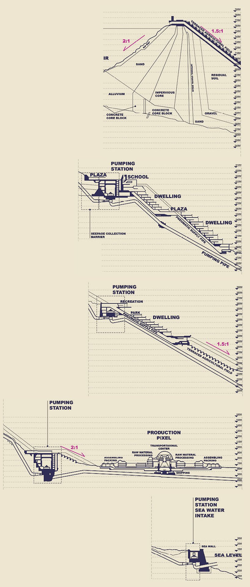
Topography study examining how topography supports the integration of natural and artificial water systems.
Pixel Urbanism:
Translating Data and Satellite Imagery

A close-up of the twin state’s pixel composition overlays the proposed landscape, a recalibration of distribution that challenges local formats.

Diagram illustrating the contrast between existing monoprogrammatic distribution and the twin state’s proposed pixel-based urbanism model.

Analysis of figure-ground relationships and circulation patterns derived from style transfer images.

A series of style transfer processes exploring the transformation of visual data into new urban forms.
Bahrain’s monoprogrammatic urban layout isolates work, living, and leisure, demanding excessive travel. A hybridized model merges these functions and minimizes distance, creating more integrated communities.

Developed pixel design demonstrating how the data translation ensures the specific needs of each industry are met.

The process of translating data and satellite imagery into a pixel strategy, forming the foundational pixel structure.
Integrated Framework:
Multiprogrammatic Scheme and Public Transit

Close-up of the central mountain desalination plant, showcasing the network of distribution streams designed to optimize water flow through natural gradients.

Drawing of existing Bahrain alongside its techno-natural twin, illustrating mountainous topography and a gravity-fed system for desalinating and distributing water.
A 6’ x 8’ topographic model, projecting AI-generated mountain ranges. The live broadcast and animation projections create a continuous dialogue between the physical model and its computational counterpart, exploring the intersections of technological systems and topographic formations.

Live broadcast of the twin state model

Projections on the model

Exhibition set-up
Topography as Infrastructure:
Agriculture and Water Systems as Catalysts

A close-up of the techno-natural twin state, where open water systems resembling streams extend the desalination infrastructure, and an arcade system connects communal pixels through a network of elevated paths.

A map of Bahrain alongside its envisioned techno-natural twin, where a reimagined topography exaggerates mountain ranges to serve as both vertical monuments and a comprehensive water infrastructure system.
